The official observations of U.S. personnel when they entered New Mexico during the U.S. War on Mexico were often times focused on how New Mexicans were dressed, what crops New Mexicans grew, what food they ate, and whether New Mexicans were “good looking.”  Every one in New Mexico was a specimen of whatever cultural or racial category was in the heads of these outsiders.

“Mr. Stanly accompanied me, for the purpose of sketching one of the women as a specimen of the race. I told the alcalde our object, and soon a very beautiful woman made her appearance, perfectly conscious of the purpose for which her presence was desired. Her first position was exquisitely graceful, but the light did not suit, and when Stanly changed her position, the charm of her attitude was gone.”

NM_Indian_Woman

Click image to enlarge.

(Above page from Lt. Col. W.H. Emory, Notes of a Military Reconnoissance, lithographs by C.B. Graham and drawings by John Mix Stanley, Ex. Doc. No. 41, Thirtieth U.S. Congress (1848), courtesy of the Prelinger Library)

It is almost common knowledge in Mexico and the U.S. Southwest that a significant number of indigenous persons in North America were forced or otherwise coerced into involuntary servitude. Modernly, since the 1970s, fourth grade students in California have been taught, reductively, that the Spanish mission system was bad because the Franciscan friars enslaved the “Indians.”

The history of the indigenous, mestizo and Hispanic populations of North America, however, remains largely ignored by U.S. East Coast book publishers. Big narrative history in the U.S. is usually told from East to West – not West to East – not from Mexico to New Mexico. Race is usually discussed in terms of “black” and “white,” with African persons often times described as objects. In such a marketplace, Andrés Reséndez’s book on Native American slavery begins:

“The very word ‘slavery’ brings to mind African bodies stuffed in the hold of a ship or white-aproned maids bustling in an antebellum home.”

Perhaps, Reséndez wrote this sentence as a point of reference for a ‘white’ audience. His title The Other Slavery: The Uncovered Story of Indian Enslavement in America may have been crafted for the same audience. It is an odd title. When slavery resonates as close family history, it is “our slavery” or maybe “another slavery”, rather than the “other slavery.”

Parral archive document on taking Apaches from New Mexico, cited by Reséndez

Document on transporting Apaches from New Mexico, cited by Reséndez.  Courtesy of Parral Archive, Fondo Colonial, AHMP.FC.A08.001.012.  Click to enlarge.

Many talented scholars and writers have explored the subject of Native American slavery, as Reséndez’s endnotes show. Yet, given the marketplace, Reséndez pitches his book as the never-before-told story on slavery in the Americas. He should not have to do this.

Reséndez’s book is a big deal. It is a big deal not because of the big event pitching. It is a big deal because Reséndez effectively and creatively synthesizes the many sources on the important subject of Native American slavery. It is a difficult task to encapsulate five hundred years of unruly, complex, insane circumstances into one tight book. Reséndez does this well.

In broad stroke, Reséndez writes about certain indigenous nations in the Americas who practiced captive-taking and slavery, and engaged in slave trading with other indigenous nations and with Spaniards. Despite the prohibitions of the Spanish monarchy, Spaniards imposed slavery and indentured servitude on Native Americans working in households, mines and on farms. Later, other Europeans and U.S. citizens, who encroached into Spanish and Mexican territories, engaged in the same activities.

The strongest parts of his book are those that tell the stories of individuals: the “Indians” Maria, Pedro, Beatriz, Catalina and others who moved (or were taken) to Spain and filed lawsuits in the hope of gaining their freedom; the Spanish monarchs Philip, Mariana and Charles who each issued orders prohibiting Indian slavery.

Reséndez considers New Mexico as having been a focal point of North American slave activity, with the territory infiltrated by Spaniards for the purpose of finding slaves for the silver mines of northern Mexico. Several governors of the province, he explains, were involved in the slave business. Reséndez posits that the 1680 Pueblo Revolt in New Mexico was, to a large extent, a revolt against slavery. This is a credible characterization.

Readers may find it troubling that Reséndez concludes that the [Pueblo Revolt] “rebels did not engage in … indiscriminate killing,” when he summarizes the killing of women, children, and servants by the same rebels. A few speculative assumptions may also annoy. Reséndez uses a 1680 muster roll of New Mexican households to suggest that most of the survivors of the revolt were slave owners. He makes no distinction between slave and servant, and assumes that all servants in New Mexico were indigenous (none being Spanish or part Spanish). By ignoring the details and distinctions, Reséndez has missed an opportunity to bring even more depth to his work.

A research copy of the 1680 muster roll of New Mexican families (from Hackett & Shelby, Revolt of the Pueblo Indians), cited by Reséndez is available HERE.

Sonja Sonnenburg de Chávez


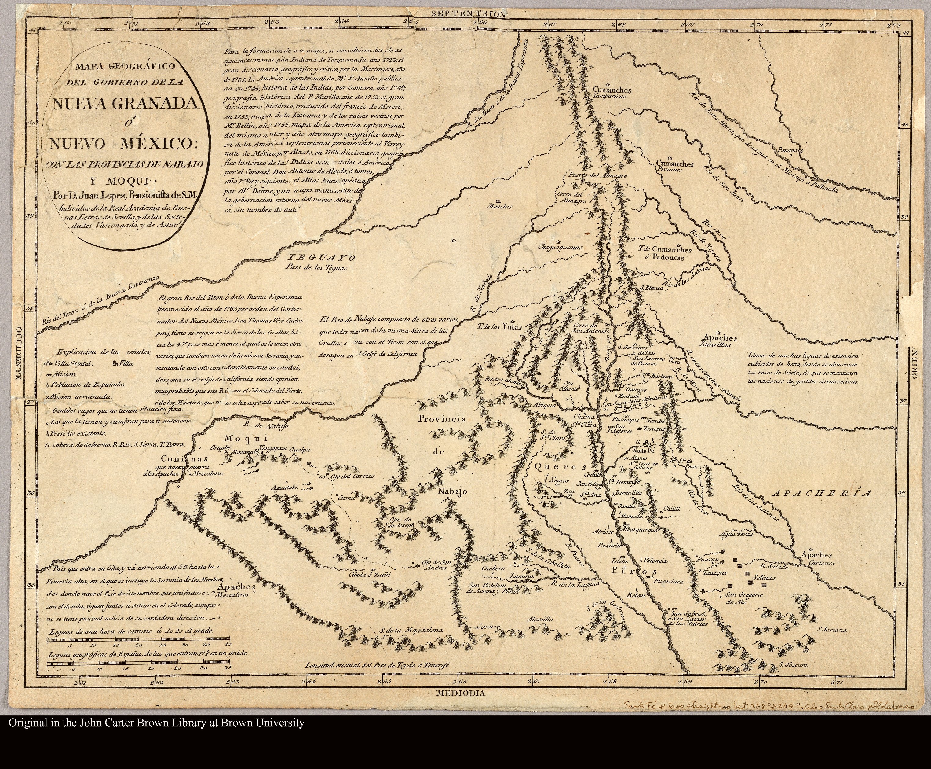
In 1795,[1] without leaving the continent of Europe, Juan Lopez of Spain created a map titled Mapa Geográfico del Gobierno de la Nueva Granada ó Nuevo México con las Provincias de Nabajo y Moqui.[2] The title seemed to suggest a sense of adventure, that it was fine to embrace uncertainty and the unknown.  (Click images below to enlarge.)

Lopez_Juan

Although his map reflected locations of Spanish influence, Juan Lopez did not exaggerate the influence. His map reflected areas of coexistence, violence and potential violence.

From thousands of miles away, Lopez charted out vast regions controlled by indigenous nations. He imagined the “Apachería,” the “Teguayo,” the “Provincia de Nabajo.” He imagined Spanish missions and settlements within the lands of the Piros and Queres.

To the east, there were vast grasslands where bison grazed; to the west, great rivers that extended so far that they reached, past the margins of the map, to the Gulf of California.

Juan Lopez’s map was authoritative — not because it was a correct geographical representation — but because it was based on many documentary authorities. Lopez claimed to have consulted many sources:

Lopez_Juan_notes

One source was Juan de Torquemada’s Monarquía Indiana (1723), an extensive seven-volume treatise on indigenous Mexican history, culture and traditions, first published in 1615.[3] Volume 2 contained four chapters on New Mexico,[4] which were based in significant part on the letters of fray Francisco de San Miguel and fray Juan de Escalona,[5] who both had spent time in New Mexico and were critical of Juan de Oñate.[6]

The 1723 printing of Monarquía Indiana contained at least one map.

torquemada_mapa

New Mexico was represented as a huge blank space.[7]

Mapa_Torquemada_close

Of all the sources he relied upon, Juan Lopez relied most heavily on the work of the French royal cartographer Jean Baptiste Bourguignon D’Anville.[8] This was due to a genealogical connection.

Amérique_Septentrionale

Above, closeup of Jean Baptiste Bourguignon D’Anville’s Amérique Septentrionale (1746) [9]

Years earlier, Juan’s father, Tomas Lopez, had studied cartography under D’Anville and later served as the royal cartographer of Spain. D’Anville and Tomas Lopez practiced “desk cartography,” a method of making maps based on field surveys, formal accounts, and a bit of creative license.[10]

Cover_Atlas

In 1758, while studying in Paris, Tomas Lopez created the Atlas Geographico de la America.[11] He dedicated the atlas to Don Fernando VI, Rey de España y de las Indias [King of Spain and the Indies], whose portrait graced the first page of the book. Chapter 3 featured El Nuevo Mexico, which Tomas described as a fertile land for growing wheat, corn and saffron and where “salvages que llamaban antiguamente Apaches … estan haora mucho mas civilizados” [savages once called Apaches … are now more civilized].

NM_Atlas_Geographico

Later in his career, Tomas flourished the corners of his maps of the Americas with dreamy drawings of palm trees, parrots, and alligators.[12] Empire and fantasy overlapped on paper and in life.

In 1780, Tomas created a map of the adventures of Don Quixote,[13] based on the novel by Miguel de Cervantes.[14] Somehow it was fitting that the royal cartographer of Spain would create a map based on fiction critical of the Spanish Empire, written almost two hundred years earlier by a man who suffered through brutal war and captivity and whose petition to live in the Americas was denied.[15]

Mapa_Don_Quixote_y_los_Sitios_de_sus_Aventuras

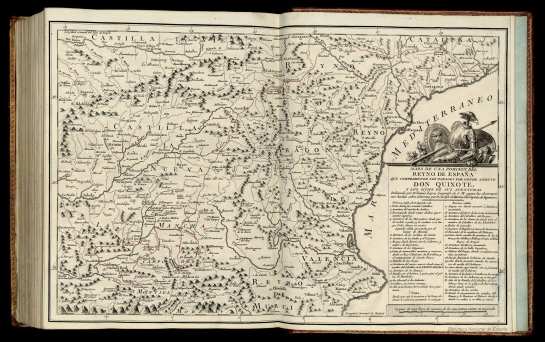
Cervantes set into motion the creative melding of fact with fiction, laughter with trauma, reality with illusion.[16] This practice flowed into most art forms. [17]

All in all, the tone of Don Quixote and the Spanish maps of the Americas (and New Mexico) was that the world to be desired was an alternative one.  The Spanish people wanted something different — and they were going to get it — whether they had to travel thousands of miles by sea, on land, or in their heads. 

Sonja Sonnenburg de Chávez


[1] This was the same year that Spain and the United States negotiated the treaty of San Lorenzo, which set the stage for U.S. territorial expansion. U.S. Secretary of State, Office of the Historian, Treaty of San Lorenzo/ Pinckney’s Treaty, at https://history.state.gov/milestones/1784-1800/pickney-treaty

[2] A high-resolution, downloadable digital copy of the map is available at the John Brown Carter Library site at http://jcb.lunaimaging.com/luna/servlet/s/n1j24v

[3] Juan de Torquemada, a Spanish Franciscan priest, learned Nahuatl during his studies in Mexico City and derived much of his knowledge for his treatise from indigenous scholars and teachings. The full title of the treatise was Los veinte y un libros rituales y monarchia indiana. An annotated copy of the 1723 printing of Monarquía Indiana, Indian Monarchy, is available on the Internet, thanks to the Instituto de Investigations Historicas at the Universidad Nacional Autonoma de Mexico. http://www.historicas.unam.mx/publicaciones/publicadigital/monarquia/

[4] Monarquía Indiana, Vol. II, Libro Cuarto, Capítulos XXXVII-XL, pp. 448-461, http://www.historicas.unam.mx/publicaciones/publicadigital/monarquia/volumen/02/mi_vol02.html#Libro04.

[5] For Torquemada’s citations to the letters of San Miguel and Escalona letters, see Monarquía Indiana, Vol. VII, Tablas de Análisis, Libro V, http://www.historicas.unam.mx/publicaciones/publicadigital/monarquia/volumen/07/miv7013.pdf

[6] Cibola Project recently published a transcription and copy of one of Escalona’s letters. See Fray Juan de Escalona, Comissary of the Franciscan Missions of New Mexico, to King Phillip III Concerning Conditions in the New Colony October 15, 1601, at https://escholarship.org/uc/item/8z94h2j8

[7] Descripción de las Indias occidentales, Monarquía Indiana, http://www.historicas.unam.mx/publicaciones/publicadigital/monarquia/volumen/01/01Preliminares/miv1013.pdf

[8] Juan Lopez also noted that he relied on: Pedro Murillo Velarde, Geographica Historia (1752) (discusses New Mexico history at Vol. 9, pp. 169-185, http://bdh.bne.es/bnesearch/detalle/bdh0000000396; Francisco Lopez de Gomara, Historia de la Indias (1552) (Gomara never traveled to the Americas; his book was criticized by Bartolome de las Casas, who disliked its praise of the Hernan Cortes, and banned by the Spanish Crown but later republished several times over the course of three centuries), http://bdh.bne.es/bnesearch/detalle/bdh0000186963, Antonio de Alzate, Nuevo mapa geographico de la America septentrional, perteneciente al virreynato de Mexico dedicado à los sabios miembros de la Academia real de las Ciencias de Paris por su muy rendido servidor, y capellan (1769), http://jcb.lunaimaging.com/luna/servlet/s/7348fm

[9] Jean Baptiste Bourguignon d’Anville, Amérique Septentrionale available at Biblioteca Digital Hispánica, Biblioteca Nacional de España, http://bdh.bne.es/bnesearch/detalle/bdh0000040949

[10] For more on the map-making methods of Thomas Lopez, see C. San-Antonio-Gomez, et al., Tomas Lopez’s Geographical Atlas of Spain in the Peninsular War: A Methodology for Determining Error. http://oa.upm.es/14061/2/INVE_MEM_2011_120868.pdf

[11] Tomas Lopez, Atlas Geographico de la América Septentrional y Meridional : Dedicado A la Catholica Sacra Real Magestad de el Rey Nuestro Señor Don Fernando VI (1758), available at Biblioteca Digital Hispánica, Biblioteca Nacional de España, http://bdh.bne.es/bnesearch/detalle/bdh0000001391. Tomas was also known for his Atlas Geográfico de España, which was published after his death by his sons. http://bdh.bne.es/bnesearch/detalle/bdh0000001859

[12] See e.g., Tomas Lopez, Mapa General de América, ó Hemisferio Occidental que contiene los nuevos descubrimientos y rectificaciones de los anteriores (1772), available at Biblioteca Digital Hispánica, Biblioteca Nacional de España, http://bdh.bne.es/bnesearch/detalle/bdh0000036038

[13] Tomas Lopez, Mapa de una Porcion del Reyno de España que Comprehende los Parages por Donde Anduvo Don Quixote y los Sitios de sus Aventuras (1780), at Biblioteca Digital Hispánica, Biblioteca Nacional de España, http://bdh.bne.es/bnesearch/detalle/bdh0000193109

[14] Miguel de Cervantes Saavedra, El ingenioso don Quixote de la Mancha (1605), available at Biblioteca Digital Hispánica Biblioteca Nacional de España, http://bdh.bne.es/bnesearch/detalle/bdh0000042946

[15] Petition of Miguel de Cervantes (1578), Expediente sobre los méritos y servicios de Miguel de Cervantes Saavedra, Archivo General de Indias, Patronato, 253, R.1. Click HERE.

[16] As Edith Grossman explained, Don Quixote was “the book that crystallized forever the making of literature out of life and literature, that explored in typically ironic fashion, and for the first time, the blurred and shifting frontiers between fact and fiction, imagination and history, perception and physical reality, or that set the stage for all Hispanic studies and all serious discussions of the history and nature of the novel. Edith Grossman, Translator’s Note to the Reader, in Miguel de Cervantes, Don Quixote: A New Translation by Edith Grossman (2003).

[17] For more on Don Quixote as a major cultural phenomenon and its continuing relevance, see Ilan Stavans, Quixote: The Novel and the World (W.W. Norton & Company 2015).

Nicolas Lafora kept a diary while he was traveling with a military inspection team in Mexico, from Tepozotlán to New Mexico between 1766-1768.  He also made a series of maps.  His diary and maps reflected his overall impression that the settlements and pueblos of “Nueva España” were predominately and diversely indigenous.  His diary was copied a few times, and then bound into books.  One of these books (dated 1768) is maintained at the Biblioteca Nacional de España (BNE) in Madrid and was recently digitized and made available online — click HERE.

lafora_cover

The title page, translated into English, says “Report of the Journey which by Order of the Most Excellent Viceroy, the Marquez de Cruillas, made by the Captain of Engineers Don Nicolas de Lafora, in Company of the Field Marshall Marquez de Rubi, commissioned by His Majesty to review the Interior Presidios Situated on the Frontier of the Part of North America belonging to the King.”

lafora_title

Below is one of the several pages on New Mexico (click to enlarge).  Based on Lafora’s estimates and observations at the time, New Mexico had 37 settlements, 2,703 families of Teguas, Genizaros, Tiguas, Abiquius, Pecuries, Taos, Pecos, Tanos, Zuñis, Acomas, Moquinos, Queres, Xemes, Sumas, and Piros, amounting to 10,524 persons.  The number of “Spanish” came to 9,580 persons, distributed among 1,487 families.  The total number of “souls” was 20,104.  According to Lafora, the “Indios” as well as the Spanish were well prepared for war, as they learned to use weapons and ride horses when they were young.  They did this to defend themselves against the “Naciones Gentiles” (probably referring to those persons who he called “Apaches Gileños” and “Pharanoes”) who surrounded them, except to the south near Nueva Viscaya at a place called Las Boquillas.

NM_Reyno_Lafora

(Courtesy of the Biblioteca Nacional de España)

The Cíbola Project is one of the most important scholarly projects on New Mexico in my lifetime. With the mission of creating access, the Cíbola Project team locates significant documents from the Spanish colonial period and expertly transcribes those documents using their high-level paleographic skills. These transcriptions are then published — along with copies of the original documents — as downloadable PDF packets. These packets are available free to the public via the University of California’s California Digital Library: http://escholarship.org/uc/rcrs_ias_ucb_cibola.

 Zamora_page_transcription


(Above left, archive document from the proceeding against María de Zamora, Ana Ortiz and María.  Above right, excerpt from Jerry Craddock’s transcription of the same document.  Click to enlarge.  From Cibola Project’s Witchcraft in San Gabriel: The Trial of María Zamora, New Mexico, 1607)

Read More

Most the people who fled (or were taken from) New Mexico after the Pueblo Revolt of 1680 were of Indigenous or mixed Spanish-Indigenous background.  The vast majority of these displaced New Mexicans were in service — servants, soldiers and slaves.  Every person was held captive by the violence of the region, some more than others.  No one was safe.

The chart below summarizes some of the details of the many displaced New Mexicans ‘found’ in Spanish colonial records from Casas Grandes to Valle de San Bartolome.  (This particular chart does not include New Mexicans who were living principally at Paso del Norte at the time, and does not make distinctions between those who returned and did not return to New Mexico.)  It is one of my many work-in-progress charts created to study and map Spanish colonial records for one of the books I am writing.  It is my attempt to make sense of the circumstances and see the unwritten in the written record. To promote access and discoverability, the chart contains hyperlinks to hundreds of archival records and other sources.

Read More

At the time the U.S. invaded New Mexico, the bridge at the Pueblo of San Felipe was swept away.  The river ran rapidly and was about four feet deep.

San_Felipe_Pueblo

(Cite: Report of Lieut. J.W. Abert, with illustration, circa 1846.)

In about 1684, Pedro II Duran y Chaves[1] and his extended family moved to the valley of Coyachic in the larger region inhabited by the Alta Tarahumara and other indigenous groups. This move into the region by the Duran y Chaves family and other families of New Mexico required deft negotiation with Spanish colonial authorities and local indigenous groups.

Years earlier, certain indigenous groups near and in the valley of Coyachic killed several Jesuit missionaries and devastated some of the indigenous pueblos administered by the Jesuits.[2] More immediately, in May of 1684, Sumas, Mansos and other indigenous groups attacked the mostly New Mexican community at Janos and Casas Grandes. Reports of the attacks at Janos-Casas Grandes quickly circulated in northern Nueva España.[3] The extended Duran y Chaves family and their friends would have been particularly sensitive to such reports, as they were violently displaced and still traumatized by the Pueblo Revolt in New Mexico in 1680 and 1681.[4] Peace was paramount.[5]

Read More

The Fondo Colonial of the Parral Archive (now online) reflects a paper and archival culture — one that valued the making and keeping of correspondence, reports, summaries, indices and the details. The imaging of this collection captures stories and drama, as well as the beauty of handwriting, creases, spots and stains. It is truly a precious gift to historians, independent scholars and to the descendants of those represented in the records.

There are many records in the Fondo Colonial for persons interested in New Mexican history, and the interconnection between Nuevo Mexico and Nueva Viscaya.  For example, there is a set of records from 1696 related to Bartolome Gomez, an indigenous man of the Piro nation, asking for lands near the lands of Tomas Chavez and near the mines of Santa Rosa de Cusihuiriachi.  Bartolome Gomez, Tomas Chavez, and Sebastian Herrera – all from New Mexico – signed documents in this particular set of documents.  (Years earlier, these men and their families had fled south from New Mexico during the Pueblo Revolt of 1680.)

Bartolome_GomezFor more, visit the Fondo Colonial, seccion Gobierno y Administration, serie Minas y Terrenos, AHMP.FC.A17.018.394, by clicking HERE.

Thanks to the Parral Archive and the Hispanic Heritage Project!